The language of the landscape is complex and multi-layered but once understood it can unlock a world of hidden meaning.
Towards the end of last year a series of artworks appeared along the Dorset coast path from just outside Lyme Regis on the border with Devon all the way to Abbotsbury. These distinctive pieces are parish boundary markers, created by local artists and makers, to let walkers know when they pass from one parish to the next.
The project is part of Dorset Coastal Connections, a connected portfolio of 18 projects that aims to boost the local economy, and couldn’t have been achieved without the input and support of local landowners and grant funding from the Coastal Communities Fund and partner organisations, coordinated by the Dorset Coast Forum.
“The brief was to create practical functional parish boundary markers that are beautifully crafted and speak to the landscape they stand in and I think we have done that,” says Tara Hansford, Dorset Council’s Countryside Access Improvements Officer.
“For many people walking along the coast path the focus is often on the seascape – looking out onto that amazing body of water and the beautiful narrow strip of coastal headland. This project hopes to also encourage the walker to look inland and gain a better awareness about the landscape they are passing through.”
For Tara this is an intensely personal project, a distillation of her professional background in the arts and environmental conservation as well as her deep-seated connection to the West Dorset landscape.
“I grew up in Toller Porcorum and come from a long line of farmers, builders and teachers in the Kingcombe Valley so this is the landscape I adore and when I’m in it I can sense the generations that have gone before me – it’s a profound connection.
“The inspiration for this project comes from my granddad, who was a builder. As a child he used to take me out in his little blue truck visiting villages to price up work. On the way he would often point out various features in the landscape – obviously hand crafted – and tell me what they meant, literally reading the landscape. He was a wonderful storyteller so he’d show me mason marks, for instance, and tell me who built a particular wall, passing on the history of the people and the landscape that have created this wonderful part of the world in which we are so lucky to live.
“It was fascinating to discover a rich cultural patina of local interest and character.”
Tara was determined the new parish boundary markers would introduce something uniquely local that reflects the landscape and local history, but also be part of the here and now.
“Whilst I appreciate art in the landscape I prefer art and craftsmanship that have a practical affinity, that become part of the landscape as opposed to artwork imposed on the landscape for its own sake. I didn’t want QR codes and interpretation boards, the idea is for people to come across the markers on their walk and wonder about them. They have an air of mystery and will weather over time as they are shaped by the elements and by human interaction. Perhaps in time they will take on their own folklore as people adopt them.
“All too often, the details that create a sense of local interest and character are lost and replaced by monotonous mass-produced infrastructure. I wanted to bring some beauty and heritage to the landscape that I love, that I’m embedded in, so I’m thrilled and relieved at how well this project has been received – we have had hundreds and hundreds of positive comments, especially on social media.”
Such was her enthusiasm that Tara found local landowners and artists were only too willing to engage with the project and feed back their own stories. Few can know the landscape better than those who live and work in it – people like Ellen Simon of the organic mixed Tamarisk Farm at West Bexington, founded in 1960 by her parents Arthur and Josephine Pearse.
Three of the sculptures mark parish boundaries on the land they farm, but artist Sarah Hough’s wind vane marker at Swyre has a particular resonance.
“From childhood I have known that there was once an isolated house on the back of the beach near the mere,” says Ellen. “My eldest brother and I used to pore over the Chesil there, looking for signs of building or fragments which might have come from the White House. It is shown on old maps and we eventually found an old print that shows what it looked like, but we never saw anything tangible on the beach.
“The sculpture puts that right, with an artist’s interpretation of the house, its purpose as a refuge and its destruction. It marks the boundary between Swyre and Puncknowle, where the West Bexington reed bed meets the mere. People walking the beach and watching the water-fowl or the starlings gathering now have an extra connection to the environment and to the past.”
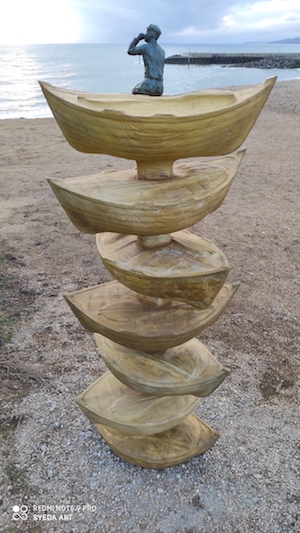
Artists too have imbued the work with personal histories that connect them to the landscape – sculptor Brendon Murless created a stack of lerret boats at West Bay that not only honours the local mackerel fishing fleet and cliff top ‘spotters’, but also his own fishing ancestors.
“My grandfather and his brothers helped fish for mackerel using seine nets off the Chesil beach, so I enjoyed including my family connection to this piece,” he explains.
“I feel the sculpture sits in harmony with the cliffs and shingle by mimicking the surrounding materials and I’m very pleased with how the public have reactedto it. I’m looking forward to watching it age and develop over time, and feel proud that my work is on display for people to enjoy in the area I grew up in.”
THE BOUNDARY MARKERS
1. Devon into Dorset, Ware: A celebration of Mary Anning, Mary Buckland and Sarah Woodruff, whose work was pivotal in establishing the reputation of Lyme Regis as the cradle of modern palaeontology. (by Alex Brooks, Emma Molony)
2. Lyme Regis to Wootton Fitzpaine. Reflecting the undulating landscape with its distinctive hilltops – Lamberts Castle, Colney Castle, Stonebarrow and Trinity, Thistle and Timber Hills. (by Alex and Ed Brooks)
3. Wootton Fitzpaine to Charmouth. Remembering Mary Anning’s discovery of the first correctly identified ichthyosaur in the Charmouth mudstone cliffs. (by Greta Berlin)
4. Charmouth to Stanton St Gabriel: A commemoration the reputed 836 Danish Viking landings on Charmouth beach. Approaching the gate the Viking warships align with the horizon taking the visitor back in time to witness the fleet of raiders advancing on the shore. (by Alex Brooks, Emma Molony, Tara Hansford)
5. Stanton St Gabriel to Chideock. The seat sculpted from local fallen trees echoes the weathered trees and hedgerows and invites locals and walkers to sit and connect with their surroundings. (by Isla Chaney)
6. Chideock to Symondsbury. Suggesting the shape of a barrel the piece invites visitors to stop and consider the coast’s rich history of smuggling. (by Delphine Jones)
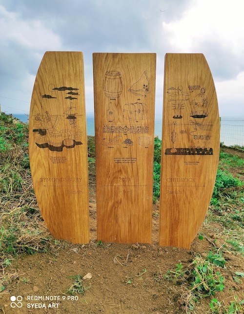
7. Symondsbury to Bridport. A tribute to the Bridport Wildcats, a group of women net makers who went on strike in protest of a pay cut and secured the support of the townsfolk. (by Alice Blogg)
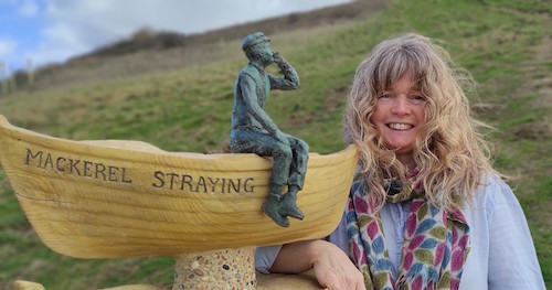
8. Bridport to Burton Bradstock. Honouring the ‘spotters’ stationed on the cliff top at West Bay to identify shoals of fish. A shout of ‘Mackerel straying!’ would prompt the fishermen to launch their boats. (by Brendon Murless)
9. Burton Bradstock to Swyre. With its smooth, bleached and dark, jagged elements, this is inspired by how this landscape changes through the seasons, distorting trees that grow to provide distinctive boundary markers for future generations. (by Alice Blogg)
10. Swyre to Puncknowle. In the 17th century a building known locally as the White House stood on Chesil Beach to provide refuge for shipwrecked sailors. The boundary marker that now remembers that house will also help walkers brace themselves in windy weather. (by Sarah Hough with metal worker/forger Will Pinder and carpenter Jake Reilly)
11. Puncknowle to Abbotsbury. Spiral tassleweed, common mouse ear, toothed medick – this boundary marker celebrates the fascinating names of the remarkable plants supported by The Fleet and Chesil Beach. (by Andrew Whittle)
THE PARTNERS
The parish boundary markers project is a positive collaboration between the local authority, local artists and craftspeople and West Dorset’s landowners.
Makers: Greta Berlin, Alice Blogg, Alex Brooks, Ed Brooks, Isla Chaney, Tara Hansford, Sarah Hough, Delphine Jones, Emma Molony, Brendon Murless, Will Pinder, Jake Reilly, Andrew Whittle
Landowners: Lyme Regis Golf Course, The Loosemore family, The Cook family, The Extons of Downhouse Farm, The Yeates family, Tamarisk Farm and National Trust
Local authority: Tara Hansford, Dorset Council Countryside Access Improvements Officer; Bran Acres, Dorset Coastal Ranger; Cleo Evans, Arts & Environment Lead, The Arts Development Company
• First published by Dorset magazine.